Eve : The wet sand at low tide stretches out through the fog. And we’re off, chasing the sunrise.
We stop off for some sightseeing at Murphy’s Haystack and Ted observes the vast expanses of this land from the comfort of Chewie’s backpack. “She’s dragged me everywhere, since that Xmas when she first grabbed my ear and dragged me towards her. Now he’s doing it too. Although I must say, this is pretty good stuff.”
We stop off for some sightseeing at Murphy’s Haystack and Ted observes the vast expanses of this land from the comfort of Chewie’s backpack. “She’s dragged me everywhere, since that Xmas when she first grabbed my ear and dragged me towards her. Now he’s doing it too. Although I must say, this is pretty good stuff.”
 Ted gets to ‘walkabout’
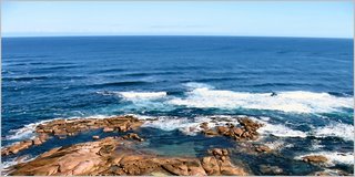
 Relaxing at Murphy’s Haystacks
 Murphy's Haystacks

Murphy’s Haystacks
Two white-bellied eagles, quite rare from what we have read, circle above the coastal cliffs with the fading half moon (still high in the sky in the afternoon) behind them. This has to be a memory picture. It takes time to stop. Even at 50 kmp/h.
Point Labatt Conservation Park is definitely worth a looksie. (‘Looksie’ is from the phrase: ‘Look. See?’) From the lookout on the cliffs, high above the beach, a sea-lion breeding colony relaxes in the afternoon sun. A young pup calls out to mum. A bull rolls over lazily on the flat rocks, while sharks lurk out in the ocean.
Point Labatt Conservation Park is definitely worth a looksie. (‘Looksie’ is from the phrase: ‘Look. See?’) From the lookout on the cliffs, high above the beach, a sea-lion breeding colony relaxes in the afternoon sun. A young pup calls out to mum. A bull rolls over lazily on the flat rocks, while sharks lurk out in the ocean.
 Point Labatt Sea Lion colony with a view over the Southern Ocean
 Sea Lion siesta
 No human footprints on this beach
Osca : This park and aquatic reserve protects a special colony of Australia’s only endemic pinniped (seals and their relatives), as this is the only site where the Australian sea-lion breeds on the mainland. These sea-lions are Australia’s most endangered marine mammal and one of the rarest pinnipeds in the world.
Point Labatt was dedicated as a reserve in 1973 as a result of the concerns of the owners, Ellen, Myra and Ron Freeman, that illegal shooting was threatening these endangered mammals. They donated the land to the South Australian National Parks and Wildlife Service so that the seal-lions could be better protected.
Eve : Cotton wool ball clouds glide over the horizon. The sand dunes atop the coastal cliff are behind us. The vegetation changes. The sun beats down, drying off yesterday evening’s drizzle.
On a gravel, unsealed, road the conditions are always changing. Here it is like it was corrugated iron, where the dips and grooves form as vehicles drive along them, weathering them down into this corrugated pattern. Let’s just say it’s quite bumpy, at any speed. (Out here Chewie averages anywhere between 10 km p/h and 50 km p/h. He stops quite frequently.)
 More like 10km per hour along THIS STUFF
Ted thinks that the passing drivers are quite enthusiastic in returning his waves. I see their faces stretch into broad smiles as he does.
As Chewie walks off into the distance to capute yet another perfect shot, those cotton wool ball clouds gather and reflect in the calm waters of the bay. “Tidyoo, tiddy – yoo. Eet, tee tee, eet.” Or ‘chirp, chirp’, for clarity.
As Chewie walks off into the distance to capute yet another perfect shot, those cotton wool ball clouds gather and reflect in the calm waters of the bay. “Tidyoo, tiddy – yoo. Eet, tee tee, eet.” Or ‘chirp, chirp’, for clarity.
 ‘Cotton wool ball clouds glide over the horizon’
Scattered windmills grace the landscape. This time sand dunes supply the backdrop.
 A scattered windmill
We stop at Streaky Bay for phone calls and supplies. There’s no digital mobile coverage here, so we make good use of our change containe, before we take a walk along Perlubie beach. I understand why the beaches seem so white here. At a closer look the sand is mingled with tiny white shell. And you ought to check out the view from this swing. “Sky, horizon, beach, horizon, sky, horizon, beach, horizon sky”, the swing squeaks rhythmically as I float through the air. I let my head drop back and watch the clouds in the sky move back and forth. I feel as if I were eight years old again.
 ‘Sky, horizon, beach, horizon…’
We arrive in Ceduna at the end of the day and settle in one of the many caravan parks for the night. In the morning Chewie has a long hot bath, which releases his tense shoulders and neck. He caught a chill the other evening and the driving and holding camera steady and updating blog and sleeping in a smaller than usual space, has given him a ‘pain in the neck’.
 Sunset over Murat Bay
 Osca : Set on the shore of Murat Bay, Ceduna, with a population of just over 3,800 is the westernmost town of any size in South Australia. The name Ceduna is a derivative of an Aboriginal word “Chedoona” meaning “a resting place”. It is a fitting name as it is the ideal place to finalise preparation for the journey across the Nullabor to Perth (some 2,000km).
Ceduna was proclaimed a town in 1896. It’s original name Murat Bay was given by a French explorer Nicholas Baudin, in 1802. The original settlement was at Denial Bay, about 10km west of the present Ceduna. Provisions for the early pioneers were unloaded from ships anchored just off shore and brought onland in wagons at low tide. For some time, the Denial Bay pier was the second longest in South Australia.
Eve : In the bright morning 47 carriages, carrying gypsum (used to break up clay into soil), clattered past along the railroad track. “How’s the ticker mate?” the engineer joked in a typical ausiie larikan way, having just scared the heck out of Chewie, making him jump, as he blew his engine horn.
 “How’s the ticker mate?”
As we drive into the center of the town we have our first sighting of aboriginal people.
Ceduna seems a sad place. The people do not seem as open and friendly as in Coffin Bay. I’m not sure why as yet.
But just on the other side of the small bay lies Denial Bay. A brightly coloured playground and a long jetty (once the second longest in South Australia) greet us. I see pairs again.
The silos of Ceduna, which is surrounded by cereal country, dominate the view.

View from Denial Bay
No comments:
Post a Comment